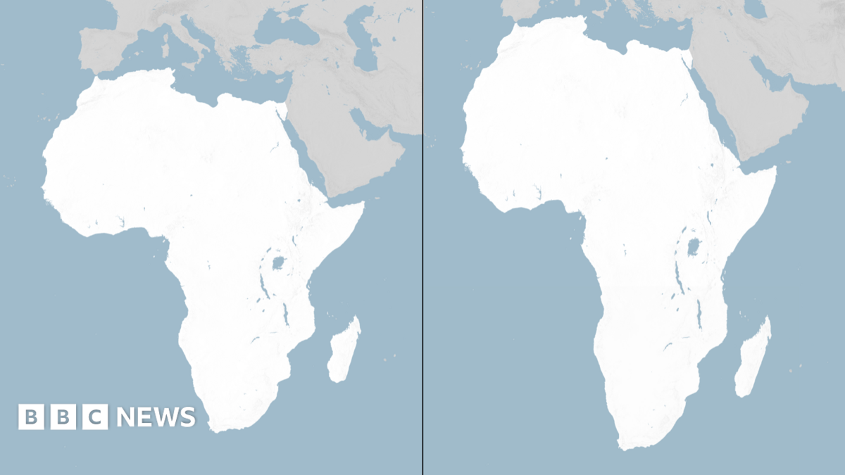
In a significant move aimed at correcting historical inaccuracies in global mapping, the United Nations General Assembly has voted to adopt a new world map that more accurately reflects the true size of Africa. The resolution, dubbed "Correct the Map," was sponsored by Togo and received overwhelming support from 164 nations, with the United States being the only country to vote against it. Six other nations chose to abstain from the vote.
The Mercator projection, which has been in use since the 16th century, has faced criticism for its misleading representation of the sizes of countries and continents. This map portrays Africa as being similar in size to Greenland, despite the fact that Africa is approximately 14 times larger. Critics argue that such distortions minimize the development needs and potential of countries located near the equator, including many in Africa.
The Mercator map was originally designed by the Flemish cartographer Gerardus Mercator in 1569 to aid European explorers in navigation. However, its design leads to significant distortions, particularly for countries near the equator, which appear smaller than they actually are, while those closer to the poles appear disproportionately larger. This has long been a point of contention among geographers and policymakers alike.
In a bid to address these inaccuracies, a team of cartographers developed the Equal Earth projection in 2018, which was subsequently adopted by the African Union (AU) in February 2023. The AU's 54 member states endorsed this new map, asserting that it more accurately represents the sizes of all continents, particularly Africa. Togolese Foreign Minister Robert Dussey emphasized the importance of this initiative, stating, "A fair world begins with a fair map." He further noted that maps are not neutral; they shape perceptions and influence how the positions of peoples and continents are understood in the global context.
While the UN vote is non-binding, it is expected to lead to changes in the maps used by various institutions around the world. The adoption of a more accurate map is seen as a step towards rectifying historical injustices and promoting a more equitable representation of Africa on the global stage. This initiative aligns with broader efforts to enhance the visibility and recognition of African nations and their contributions to global development.
The resolution has garnered support from numerous countries, including France and the United Kingdom, indicating a growing recognition of the need for accurate representation in global mapping. The backing of such a diverse coalition underscores the importance of this issue not just for African nations, but for the international community as a whole.
The implications of this resolution extend beyond mere cartography. By adopting a map that accurately reflects Africa's size, the UN is also addressing the socio-political narratives that have historically marginalized the continent. The Mercator projection has often been criticized for perpetuating a Eurocentric view of the world, which can influence perceptions of power dynamics and resource distribution.
As Nigeria and other African nations continue to navigate the complexities of global politics and economics, the adoption of a more accurate map could play a role in reshaping international relations. It may also serve as a catalyst for discussions around equitable resource allocation and development strategies that take into account the true scale of African nations.
In the wake of this resolution, it will be crucial for African leaders and policymakers to leverage this momentum to advocate for their countries' interests on the global stage. The new map could provide a platform for increased visibility of Africa's potential and challenges, fostering a more nuanced understanding of the continent's role in global affairs.
Looking ahead, the focus will be on how this resolution translates into practical changes in mapping practices and the broader implications for international relations. The UN's decision may also inspire similar initiatives in other regions, as countries seek to address historical inaccuracies in global representations. the UN's adoption of a new world map that accurately reflects Africa's size marks a pivotal moment in the ongoing efforts to promote fairness and equity in global representation. As the world moves towards a more inclusive understanding of geography, the hope is that this resolution will pave the way for greater recognition of Africa's significance in the global landscape.