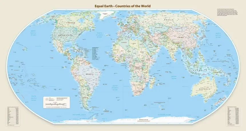
In a significant move that aims to reshape global perceptions of Africa, the United Nations General Assembly has voted to adopt a new world map that accurately represents the continent's size. This resolution, introduced by Togo and supported by all 55 African Union member states, is part of the #CorrectTheMap campaign, which seeks to address the long-standing inaccuracies perpetuated by the traditional Mercator projection.
The Mercator map, created in 1659, has been criticized for distorting the size of countries and continents, particularly in Africa's case, where it presents the continent as much smaller than it actually is. For instance, the Mercator projection depicts Greenland as roughly comparable in size to Africa, despite the fact that Africa is approximately 14 times larger. This distortion has led to what some activists refer to as "cartographic colonialism," where the representation of the world on maps reflects Western stereotypes and diminishes the perceived importance of African nations.
The newly adopted map utilizes the Equal Earth projection, developed in 2018, which aims to show countries and continents in proportions that are more reflective of their actual surface areas. This change is not merely cosmetic; it has profound implications for how Africa is viewed in the global context. By adopting this new projection, the UN aims to promote a more equitable representation of the globe's regions, particularly Africa, which has historically been marginalized in global discussions.
The resolution passed with overwhelming support, garnering 164 votes in favor, including those from Nigeria, Togo, Ghana, Morocco, and several other African nations. Notably, countries such as Germany, France, Turkey, and the United Kingdom also supported the resolution. However, the United States voted against it, describing the resolution as "superfluous," while several countries, including Hungary and Japan, chose to abstain from the vote.
Togo's Foreign Affairs Minister, Robert Dussey, emphasized the importance of this resolution, stating that it recognizes the disproportionate representations that have persisted due to the Mercator projection. He argued that the discussion surrounding this resolution is rooted in scientific evidence and should be accepted as a reality that has lasting effects on education, culture, and geopolitics. The resolution, he noted, aims to rectify the cognitive biases that have contributed to a diminished perception of Africa's significance on the world stage.
In a similar vein, France's Foreign Minister, Jean-Noël Barrot, expressed support for the resolution, highlighting the need to abandon the Mercator projection in favor of more accurate representations that align with scientific recommendations. This shift in perspective is expected to influence educational curricula and technological applications, as the Mercator projection has been widely used in classrooms and various forms of media.
The adoption of this new map comes on the heels of another significant resolution passed by the UN General Assembly, which recognized the transatlantic slave trade as a grave crime against humanity. This earlier resolution, introduced by Ghana, called for member states to consider apologizing for the slave trade and to establish a reparations fund aimed at addressing the historical injustices faced by African nations. The overwhelming support for both resolutions reflects a growing recognition of the need to confront historical wrongs and reshape narratives surrounding Africa and its people.
As the world moves towards a more inclusive understanding of geography and history, the adoption of the new map signifies a critical step in acknowledging Africa's true size and importance. It is hoped that this change will not only enhance educational resources but also foster a greater appreciation for the continent's contributions to global culture, economy, and politics.
The implications of this resolution extend beyond cartography; they touch on issues of identity, representation, and the ongoing struggle for equity in a world that has often marginalized African voices. As countries begin to implement this new projection in various sectors, including education and technology, the hope is that it will lead to a more accurate and respectful representation of Africa in global discourse. the UN's decision to adopt a new world map that accurately depicts Africa's size is a landmark achievement for the continent and its advocates. It is a reminder of the power of representation and the importance of correcting historical narratives that have long been skewed. As the world grapples with its past, this resolution serves as a beacon of hope for a future where Africa is recognized for its true stature on the global stage.